At Indits, we innovate for...
Empowering industries with geospatial insights. Revolutionizing Railways, Defense, and Government projects for a smarter, connected world.


What We Do
Pioneering solutions for a connected future
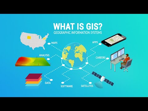
At Indits, we're at the forefront of geospatial innovation. As a leading provider of CAD, GIS, and consulting services, we specialize in large-scale mapping, GIS surveys, and satellite imagery feature extraction that's reshaping industries.
Our expertise drives transformative solutions for government organizations, with a particular focus on revolutionizing Indian Railways. As we expand globally, our commitment to precision, quality, and timely execution remains unwavering. Join us in our mission to create a more connected, efficient world through the power of geospatial intelligence.

Our Main Sectors
Expertise across diverse industries
Railways
Providing comprehensive CAD/GIS services and mapping solutions for Indian Railways, ensuring precision and compliance.
Defense
Delivering secure and efficient GIS surveys and data solutions to meet the specialized needs of defense organizations.
Government Projects
Partnering with state departments and agencies for large-scale GIS surveys, mapping, and digitization projects.
International Markets
Expanding our services globally with cutting-edge solutions in mapping, satellite imagery, and consultancy.
Our Expertise
Delivering comprehensive geospatial solutions across various sectors
CAD & GIS Solutions
Offering precise CAD and GIS services for large-scale infrastructure projects with cutting-edge technology.
Large-Scale Mapping
Specializing in accurate and compliant mapping solutions for Railways, Defense, and Government sectors.
Satellite Imagery Feature Extraction
Providing advanced satellite data analysis for urban planning, defense, and environmental monitoring.
GIS Surveys & Land Record Digitization
Conducting certified GIS surveys and digitizing land records for seamless documentation and planning.
Government & Private Consultancy
Delivering expert consultancy services for both government tenders and private sector projects.
Sustainable Liasoning
Ensuring smooth project execution through effective communication and follow-ups with relevant authorities.
Our Impact in Numbers
More Than 25 Years In The Industry creating an impact


+
Projects Completed
+
Years of Experience
+
Happy Clients
Glimpses of Past Projects
Check out glimpses of our successful projects.


Our Clients
Trusted by companies and government organizations of all sizes


Get in Touch

Get in touch our team is ready to provide expert guidance and innovative solutions tailored to your needs.
Company Name
Ind Infotech Services
Office Address
GS-5,59/60,Ashwamegh Complex, Ramdaspeth,
Nagpur,Maharashtra, India - 440010
Headquarters
Plot 4, Ayodhya Nagar,
Nagpur-440024
Sales Contact
Phone: + 91-712-6556912
Email: sales@indits.in
